
British settlement is guilty of giving all Australians citizenship power
British settlement is guilty of giving all Australians a legal citizenship power, blackfella, whitefella all the same!
Jus soli or birthright citizenship is not an automatic right in many countries around the world. For the past couple of centuries the term ‘nation’ has referred to a group of people who are geographically, culturally, and politically integrated. For them the idea of legal citizenship is powerful. It signifies a doorway to the protection of an individual and access to fundamental legal rights and financial supports.
Western citizenship unity provides a common sense of purpose, a common identity of supporting every individual’s choice to live a free and prosperous life within the societal boundaries. Being prejudiced is not evil but purposefully hurting another is outlawed. Compassion is as vital to community as clean air. The difference in others is acknowledged and used to strengthen the greater good of all concepts. Merit is a value based on a judgement of higher performance and recognition that everyone cannot do or wants to do everything to an equal performance level. Hard work and determination to achieve in spite of adversity will conquer over lazy, could not be bothered trying routines. Self-discipline is respected and coercion is rallied against.
If a person occupies a building, a tent, land, or a boat, they are an inhabitant and user of the property. The person may or may not also be the legal owner of that property.
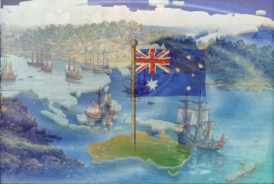
‘Terra Australis’ Incognita was thought to be a South Polar continent and means an unknown land of the south. Commander James Cook’s second voyage between 1772 and 1775 travelled more than 100,000 kilometres through the Southern Hemisphere’s deep sapphire blue ocean seas to prove there was no unknown southern continent unless it was at the pole itself. In 1820, Antarctica the mythical land to the far, far south of the discovered world was unearthed.
Cartography is the art and science of graphically visualising a geographical area, typically on a flat surface such as a map or chart.
Documented maps show Portuguese navigators viably first sighted the unknown land of the south between 1521 and 1524.
The golden age of Dutch cartography reigned from around 1606 to 1664. A time when traversing deep sapphire blue ocean seas was a dangerous calling. This was because of a high sailor death toll to disease and ships vanishing due to primitive navigation in uncharted waters. Even so, some 30 navigators from a distance and up close charted and explored the island continent they named Hollandia Nova – New Holland.
Dutch navigator William Janszoon in 1606 made the first recorded European sighting of the Australian mainland and is said to have set foot on its shores on the western side of Cape York Peninsula.
The Dutch explorers mapped discontinuous stretches of the southern, western, and northern coastlines of Hollandia Nova but made no attempt at settlement. Whether the coastline was continental and connected with the theoretical continent of the ‘south land’ remained unknown. Naught was known about the continent as a whole.
During this golden age in 1642, Abel Janszoon Tasman, seafarer, explorer and merchant was an employee of the Dutch East India Company who travelled the deep sapphire blue ocean seas to the still unexplored South and East lands. Mysterious lands expected to be full of gold and silver in a promising territory for trade along new shipping routes.
No fully authenticated portrait of Abel Tasman exists. Abel is portrayed as a visibly competent, humane, energetic and courageous commodore with Christian beliefs. He became a cautious explorer after he had a narrow escape from death when in an imprudent landing in the Moluccas archipelago, eastern Indonesia, some of his cohorts were massacred by people of Ceram.
Under his helm two ships, his flagship, Heemskerck, and an armed transport ship, Zeehaen, ventured on a Dutch expedition of discovery.
On 24 November 1642, around 4 o’clock in the afternoon, commodore Abel Tasman, close to shore, sighted the peaks of southern Tasmania’s west coast north of Macquarie Harbour. He named the locality Van Diemen’s Land. This land found in the deep sapphire blue ocean seas beyond Hollandia Nova was not known earlier to any European nation.
As a safety precaution in this unknown territory commodore Abel Tasman took the ships further out to sea when evening arrived. Over the next week the seafaring explorers proceeded south skirting and mapping the southern coastline of the island. In stormy weather the ship sheltered in a bay on the east coast near the mouth of the Derwent river.
Abel Tasman’s crew caught glimpses of smoke rising from fires from various spots on shore and heard human voices; however local natives were never actual seen by them. The explorers had no knowledge of what the local natives looked like.
On 3 December 1642, an attempt to land on Van Diemen’s Land was made but the sea was too rough. Peter Jacobsen, a carpenter volunteered to swim through the surf ashore where he embedded in the sand a pole with the Prince’s flag. Thus commodore Abel Tasman took possession of the land for the Dutch. He then navigated up the east coast to St Patricks Head before sailing eastward to find New Zealand, the Tonga archipelago, and dangerous reefs of the north-eastern part of the Fiji cluster. From here the two ships voyaged to re-explore bits of the north coast of New Guinea.
Early Spanish maps show the coast of New Guinea appropriately but exclude Australia. The first recorded European navigation of the Torres Strait was by Spanish maritime explorer Luís Van de Torres in 1606 when he sailed east to west along the south coast of New Guinea and discovered the passage of water that still bears his name.
The 1606 exploration ascertained that New Guinea was not a neck of land attached to the sought-after still uncharted great southern continent.
This information was lost or kept secret until 1769 when the Scottish geographer Alexander Dalrymple, whilst translating some Spanish documents attained in the Philippines in 1762, found Luís Van de Torres’ testimony proving a passage of water existed south of the New Guinea shoreline. Dalrymple named the passage Torres Strait.
In 1770, a British ship spent some four months sailing north and her crew mapped around 8,000 kilometres of the east coast of Hollandia Nova between Point Hicks in Victoria and Possession Island off the coast of Queensland.
On 20 April 1770, that British ship, the HMB Endeavour, with Lieutenant James Cook at the helm came across ‘a continent or land of great extent’ that was in southern latitudes. A land mass in the state in which ages before the local native people living on it had found it.
On 29 April 1770, Lieutenant James Cook and his crew made their first landing on this southern continent at Botany Bay. Explorations confirmed that the dunes and marches, surrounding Botany Bay were not the best place to establish a future British settlement.
On the HMB Endeavour, Lieutenant James Cook rounded the tip of Cape York turned south-west and landed on an island he named Possession Island. In customary ceremony he ‘hoisted English colours’, officially marking the taking possession of the east coast of Australia in the name of King George III of England.
From the top of a mound, he heralded down to the crew that he could see a navigable passage through the treacherous and turbulent reefs and shoals of the Strait. The existence of Torres Strait as a passage of water was corroborated.
There is some contention that when Lieutenant James Cook arrived in Batavia (Jakarta, Indonesia) and he learnt that the French had preceded him across the Pacific, that he changed his notes to indicate his actions on Possession Island were a possession ceremony and not merely a signalling drill.
British administrative control in the Torres Strait Islands began nearly a century later in 1862. The London Missionary Society arrived on Erub (Darnley Island) in 1871 and spread through the inhabited islands in the strait. The islands in Torres Strait were annexed in 1879 by the then British colony of Queensland.
Botany Bay’s precise latitude location and name were etched upon a map in 1770 by Lieutenant James Cook who revealed it on his first Pacific voyage on the HMB the Endeavour. Then while the Endeavour was in Botany Bay to collect water and wood Cook with a few others travelled north about 12 kilometres along a primeval track on a high costal ridge and viewed what he named Port Jackson.
The first recorded European sighting of Sydney Harbour was made by Lieutenant James Cook who saw a naval paradise, a natural deep-water defendable harbour with room for ships to manoeuvre.
The Admiralty had ordered Lieutenant James Cook to conceal strategically valuable discoveries, as such he excluded any mention of his sight of this harbour from his journal and chart. A cartographic secret about a strategic asset not to be revealed on maps or charts until Britain could afford to garrison and settle the location.
On 22 August 1770, Lieutenant James Cook claimed the whole of eastern Hollandia Nova, including Van Diemen’s land, as British possession naming it New South Wales.
Botany Bay was used by the British Admiralty as a decoy as Lieutenant James Cook had indicated an unsuitability to establish a permanent settlement there and Port Jackson was just to the north.
Lieutenant James Cook was promoted to the rank of Commander within a month of his return to England on the HMB the Endeavour in 1771.
At this point in history England and France were fierce European Empire rivals.
At that time, as a substitution for capital punishment, convicted criminals and other undesirables were transported to a penal outpost away from the motherland. England had deported around 50,000 of their ‘convict stock’ to its colonies in the Americas from 1717 until 1783.
America became an independent sovereign country on 4 July 1776.
New South Wales was a new place where Britain could transport convicted criminals because her gaols were chronically overcrowded at home, and this would fortify a base in the Pacific to counter French Empire expansion. The new outpost was to be a self-sufficient farming settlement utilising the labour of convicts banished from Britain. A motley mixture of small convict transports and store-ships were got ready for the transportation expedition.
At that time, private marines in the Britain Royal Navy enlisted for life although discharge by purchase was allowed on payment of 10 guineas.
On 13 May 1787, the British Navy and Admiralty Department, set sail from Portsmouth the First Fleet from England to establish a farming settlement and penal outpost on the east coast of New South Wales. The same place that had been explored and claimed by Lieutenant James Cook for Britain eighteen years earlier.
The first European settlement of this newly claimed land was seen as necessary because of the loss of the thirteen British Colonies in North America and Britain’s desire to preempt the French Empire from expanding into the region.
A modest, world-class seaman of forty-nine years of age, Captain Arthur Phillip, was appointed Commodore of the First Fleet’s eleven ships. The motley mixture of ships included two Royal Navy escort ships, the HMS Sirius, and HMS Supply, six convict transports, the Alexander, Charlotte, Friendship, Lady Penrhyn, Prince of Wales, and the Scarborough, and three store ships, the Borrowdale, Fishburn and Golden Grove.
A part of the British Royal Navy’s duty was to provide soldiers who were able to fight at sea and on land and assist with shipboard duties. With assent from King George III, eight months before sailing the New South Wales Marine Corps began. 34 officers and men were also to serve in Ship’s Complement of Marines aboard Sirius and Supply. Marines were placed on each transport to guard the convicts during the voyage.
The first long-term European military presence in Australia sailed within the First Fleet. Lured by a two-guinea incentive payment to volunteer together with an offer of discharge and land grants in the new settlement after three years’ service there. 106 private rank marines and accompanying officers were selected from many contenders who willingly agreed to partake in the foundation of what was to develop into the Commonwealth of Australia.
Hand-picked men all under forty years of age with a minimum height of 5’6”. Pioneering adventure seekers to be dressed in red long-tailed doublet, white trousers, black headdress, and shoes and gaiters, made up four companies of volunteer marines who were instrumental in establishing the settlements rule of law. Officers were permitted to carry swords and sidearms while other ranks were allotted Brown Bess muskets.
This pioneering group of the British Marine Corps embodied 246 men with Major Robert Ross in command of a variety of ranks: officers, sergeants, corporals, drum and fife players, and privates who all set sail halfway around the world to a place where none had any real idea of what they might find when they got there.
The Admiralty issued each convict on the first fleet with one year’s everyday clothing. No convict uniforms. Women’s clothing included skirts, jackets, caps, long sock stockings, shifts, handkerchiefs, shoes and hats. Men were issued with jackets, shirts, waistcoats, knee length breeches, above the knee socks, hats and shoes.
Ropes, crockery, agricultural equipment, ammunition, and an assortment of other stores were seen to be needed. Articles transported included tools, agricultural implements, seeds, spirits, medical supplies, bandages, surgical instruments, handcuffs, leg irons and a prefabricated wooden frame for the colony’s first Government House. Onboard provisions and stores expected to last for two years were part of the cargo along with horses and other animals from England.
The motley mix of vessels were sailing ships and the optimum passage from one place to another was not always the direct route. The direction of the wind was valuable.
The First Fleet after leaving Portsmouth briefly docked in the Canary Islands off the coast of Africa. The fleet then traversed the deep blue sapphire seas of the Atlantic Ocean to Rio de Janeiro, Brazil, benefiting from favourable trade winds and ocean currents.
During the month the fleet was docked at Rio de Janeiro an enormous store of supplies, food and water were loaded onto the ships. The ships were all cleaned and essential maintenance and overhauls were made. From here the fleet sailed back across the deep blue sapphire seas of the Atlantic Ocean to Cape Town, South Africa. Being the last port of call they took on even more food, and livestock. The convicts and crew were treated to the sumptuousness of fresh meat and vegetables. The livestock included two bulls, seven cows, one stallion, three mares, forty-four sheep, thirty-two pigs, four goats and a very large quantity of chickens, ducks, geese, turkeys, poultry of every kind. A main task at this port was to gather plants and seeds of sustenance to be planted upon arrival at the new settlement.
An all-embracing hodgepodge of people made up this celebrated “First Fleet.” Military and government officials, together with some of their wives and children, steered the troupe.
Sailors, cooks, a handful of experienced carpenters, one stonemason, one brick maker, three plasterers, five bricklayers, and other rookies hoped to begin new lives and gain prosperity in the new colony. No architects, no designers, no surveyors. Several of the marines were previously skilled workers displaced by the Industrial Revolution. Most of the convicts were city dwellers who knew zilch about farming or building construction.
The First Fleet’s journey across the deep blue sapphire ocean seas is one of the world’s greatest sea voyage triumphs. Eleven ships carrying around 1,500 people and stores travelled for 252 days for more than 24,000 km without losing a ship. The chief surgeon for the First Fleet, John White, reported a total of 48 deaths and 28 births occurred during the epic voyage.
Without the first fleet arriving in Botany Bay and landing at Sydney Cove in 1778 Australia and Australian citizenship would not exist.